« Roadside News: March 13, 2009 | Main | Roadside News: March 16, 2009 »
My Sights 2.0: E-Z Trip Planning
March 16, 2009
 We keep a bloodshot eye scanning the horizon for ways to make RoadsideAmerica.com even more wonderful. Sure, you can sit at home and chuckle along with our quips about this emu rodeo or that collection of famous inventor jaw bones. But then — you can drive there to see for yourself! RoadsideAmerica.com features thousands of easy-to-find road trip destinations, provided you have directions, a map, perhaps a GPS device. My Sights 2.0 is our latest road trip aid to help you plan and explore.
Helping the Lost and Confused
We always loathe losing half a day following vague or wrong directions to some empty lot or mountain road. And more than once, we’ve finished a trip and discovered we’d driven past several great attractions — only blocks away, just a quick jump up an exit ramp. If only we’d known.
It seemed that the most awesome, vibrating Forevertron of trip tools would be speedy online route planning for all the roadside attractions we’ve mapped. RoadsideAmerica.com released that capability last week as “My Sights 2.0.”
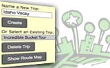
 With My Sights 2.0, you can save places as you did in 1.0, create a trip (or multiple trips), and then proceed to the new Show Route screen to finalize your trip with street-to-street directions.
Check out this example screen from a small “Rural North Missouri” trip we created. It shows map points we selected for the trip.
On the Show Route screen, we thought it was important for users to be able to move around their list places, adding more, changing the order, deleting, whatever. You can do this in the “Places in Route” box, after selecting places from the map by clicking on “+ Place in Route.”
 The second screen example shows that we’ve clicked on a number of the places, put them in our preferred order to visit, and then clicked on “Show Route” to generate the path. The path would whisk us from the Hall of Waters to the Home of Sliced Bread in 4 and 1/2 hours! We decided to skip a place originally picked out for the trip (when we plan real trips, we do this often).
We also included a way to add your own addresses along the trip — such as a start and end home address, a friend’s house, hotel address, or a new attraction you know about (and we don’t).
 The street-to-street directions provide mileage and travel time estimates just like you’re used to getting over at Yahoo or Google. We also include the attraction phone number if available.
Please remember that some attractions may not be mapped precisely, but directions should generally land you in the neighborhood. As part of the route print-out, we’ve included the original visitor-submitted directions that may include some business names, landmarks or other clues to help you pinpoint a place as a last resort.
We hope you’ll give My Sights 2.0 a try (and let us know where we can improve).
GPS POI File
Users of GPS devices can export their trip data to a file that they can load and use. Caution: Some longitude and latitude data is approximate. We recommend taking along a print-out of the full trip plan as a back-up when you end up at some empty lot or on some mountain road….
Sections: RA Site Stuff, Trip Tools 4 Comments »


March 17th, 2009 at 6:43 pm
How do I purchase and download?
March 17th, 2009 at 7:17 pm
My Sights 2.0 is part of RoadsideAmerica.com and is a free service! Try it out by mapping a city:
http://www.roadsideamerica.com/location/
for example,
http://www.roadsideamerica.com/map/az/phoenix
…just start clicking on map pushpins and checking the “Add to My Sights” checkboxes. Click on any “Show My Sights” link to see your list and start planning a trip. You can export your trip POIs.
April 23rd, 2009 at 9:45 pm
Is there an “Along the route” option? Something that will indicate attractions that are within a certain distance of the roads used. It would be best if the distance is selectable.
Thanks!
April 23rd, 2009 at 11:18 pm
We’d love to offer an “Along the route” capability, and we’re trying to come up with a good way to limit the set returned so each request doesn’t overwhelm the database. Perhaps in the next version!