 Elkins, Arkansas: Drive the Pig Trail
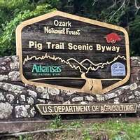
If you want to drive a route that makes your tires squeal, try The Pig Trail.
- Address:

- Hwy 23, Elkins, AR
- Directions:
- The Pig Trail follows Hwys 23 and 16, from Ozark in the south to Fayetteville in the north, roughly 60 miles of twisty-turniness.
Results 1 to 5 of 5...
Visitor Tips and News About Drive the Pig Trail
Reports and tips from RoadsideAmerica.com visitors and Roadside America mobile tipsters. Some tips may not be verified. Submit your own tip.

Yeah it's pretty twisty. Keep up with the locals and the big trucks for a truly crazy ride.
[Annie, 07/01/2021]Beautiful road through forests with a rare "town" thrown in here and there. My highlights are looking down the hill you're on and seeing where you'll be after a turn or two, and the church with tombstones reading "Abortion... Kills... Babies." It's called the pig trail, as far as what I've always heard, because it's as crooked as pig's tail. Woo Pig Souie!
[Ryan, 05/24/2010]The Pig Trail is Hwy 23. North from Ozark. It goes from Exit 35 on I-40 up over the Mulberry River (be sure to stop at Turner's Bend for a drink), past the Cass Job Corps Center to Hwy 16 at Breshears. It then makes a west turn 16 in to Fayetteville almost to the foot of the Razorback Stadium in Fayetteville. Nice drive in the summer, cool beneath the trees that shade it. A new attraction on top of the ridge is the Music Festival Park on top. They have RV and regular camping as well as a number of scheduled concerts on weekends.
[Starr Hughey, 03/03/2009]Ms Harmon's report on the "pig trail" of NW Arkansas fits with my memory of pulling a U-Haul trailer up it with a Volkswagen. Exciting. The name surely derives from the zillions of loyal Razorback fans taking this route from Little Rock to Fayetteville (or vice versa; the two alternated home games) to get screaming drunk by halftime while wearing their best suits/dresses/furs/etc. each Saturday through the football season.
[Ed Vinson, 05/14/1999]Due to some uncreativity in the advertising industry, typical car commercials almost unfailingly show you some vehicle careening around hairpin turns in what looks like a paved forest highway. Leave it to my home state to actually HAVE such a highway, dubbed "The Pig Trail" by the locals. This approx. 30-mile stretch of Hwy 16 in Northwest Arkansas lies somewhere between Ozark and Elkins. At least, these are the towns I recall which resemble civilization on either side of the "Pig Trail." I'm not sure EXACTLY why this highway was named as such, but my mother told me that it was the the highway most frequently used by big trucks carrying pigs. There is one rest stop within the span of trees, mountainous inclines, and winding turns; I believe its name is related to the "Pig Trail" theme. If you ever brave this "scenic" route, stop here or you'll be relieving yourself on a 5-foot shoulder of a road that tapers off to a VERY steep incline. Good points: the highway is scarcely patrolled; your speed depends on the turns and the car in front of you. It's quite a rush if you have a motorcycle, also. :)
[Mackalynn Harmon, 05/06/1999]Nearby Offbeat Places
Latest Tips Across Roadside America
Catch up on the latest discoveries from the road.
Explore Thousands of Oddball Tourist Attractions!
Unique destinations in the U.S. and Canada are our special obsession. Use our attraction recommendation and maps to plan your next road trip.