 Lookout Mountain, Tennessee: Battles for Chattanooga: Techno-Map
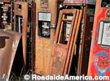
The Civil War battles for Chattanooga are recreated on a map that was built in 1957, updated with 3-D projection multimedia in 2016.
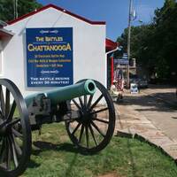
Battles for Chattanooga Museum
- Address:

- 1110 E. Brow Rd, Lookout Mountain, TN
- Directions:
- Battles for Chattanooga Museum. I-24 exit 178, (Lookout Mountain / S. Market St." exit. Take the Lookout Mountain ramp off the exit. Proceed through next two stop streets to Broad St. Turn left (south) on Broad St. Proceed to the railroad underpass. Broad St. becomes Hwy 41. Continue on Hwy. 41 about a half-mile and take the ramp on the left side of the highway labeled Ruby Falls. Continue past Ruby Falls and go straight to top of Lookout Mountain. At top of Mountain, take sharp right onto East Brow Rd. Follow signs to the end of East Brow Rd.
- Hours:
- Summer daily 9-6, off-season 10-5 (Call to verify) Local health policies may affect hours and access.
- Phone:
- 423-821-2812
- Admission:
- Adults $10.
Results 1 to 3 of 3...
Visitor Tips and News About Battles for Chattanooga: Techno-Map
Reports and tips from RoadsideAmerica.com visitors and Roadside America mobile tipsters. Some tips may not be verified. Submit your own tip.
For a mere $3 you can walk through a gorgeous little park that has the actual cannons in the actual locations where the battles occurred. You can see where they were firing at! You can also see 5 states! There are authentic cannonballs that were not fired. In the center is a monument in remembrance of both sides of the Civil War -- which from what I understand makes it unique.
This is well worth the short walk from the Incline Railway.
[Jennifer, 01/19/2008]The Battles for Chattanooga Electric Map and Museum (formerly the Confederama) is still doing fine in its new location between the top of the Incline and Point Park.
The Tennessee Civil War Museum, which used to occupy the old Confederama building has moved about a block away to a building closer to the bottom of the Incline. The old Confederama building is now a Blockbuster Video store.
[Kirby Bartlett-Sloan, 07/30/2000]The Battles for Chattanooga Electric Map and Museum (better known to Roadside America buffs as the Confederama) has moved to a higher traffic location. They are now at the top of Lookout Mountain within walking distance [of Rock City] on Point Park.
From what I can tell from the maps in the Chattanooga Visitors Guide, The old Confederama location is now The Tennessee Civil War Museum. (Tennessee Ave, Chattanooga, TN 37550 423-821-4954) The entry says "New Attraction Open Summer 98" and the map shows it down at the bottom of the mountain close to the Incline.
[Kirby Bartlett-Sloan, 06/24/1998]Nearby Offbeat Places
Latest Tips Across Roadside America
Catch up on the latest discoveries from the road.
Explore Thousands of Oddball Tourist Attractions!
Unique destinations in the U.S. and Canada are our special obsession. Use our attraction recommendation and maps to plan your next road trip.